|
And the flora and fauna living on, and above, the emerging continent, were about to be tried and tested. For the whole area was going through a gradual, but dramatic metamorphosis. Alphaland was about to incubate the first, and probably the largest swamp, too ever exist. The flora and fauna of this time and place in history had but one advantage, one great advantage, they had a long, long time to adjust to the dramatic changes that were taking place on their World. The Alphaland Swamp was where a fish first used its fins to crawl through shallow water. And where, when cattails, ferns and other plants grew thick, and stagnate land locked pools full of rotting vegetation became the norm, oxygen starved fish survived by gulping air at the water's surface. Until eventually, more than one specie of these ancestral fish developed lungs, which enabled them to breath out of water. And the Alphaland Swamp was also where, as the area became higher and drier, that the fins of crawling fish evolved into feet. Thereby allowing animals to pull themselves from one shallow water hole to another. And breathing, crawling animals, inhabited the land. Some of the ancient forms of lungfish, have changed very little since they first evolved in Alpha Swamp, and thrive in a variety of ecosystems today. Other animals, which developed lungs, and four legs, crawled from the swamp and rapidly evolved into a myriad of different species. They became the amphibians. And were the masters of their universe, for the next eon. There is no doubt, most of the lands on Earth today, except for the Ring Mountains, rose above the oceans just before, or during the Amphibian Era. Actually the settling of the ocean depths, the mid oceanic ridges, drained a great deal of water from the continents. Some continents, like Antarctica, actually gave up land during this Era. The north edge of the Antarctic Plate tilted down with the Atlantic-Indian Ocean and East Indian Ocean Ridges, and allowed water to encroach upon the Antarctica Continent. Africa tilted to the south and east and ceded some land back to the ocean. South America lost considerable area when it tilted down toward the south and west. But on the total land mass grew considerable during the Amphibian Era. The Glacier Girdle and Ring Mountains were at least periodically globally in tack. And there was sufficient inhabitable land bordering the entire Ring Mountain Range that both flora and fauna were able to freely circle the globe. And circle the globe they did. The following article from "BBC News," is just one of many articles you can easily find which will testify to this fact. Many Scientists have found reason to believe that Antarctica was once connected by a land bridge to South America, and by another land bridge to Australia. "BBC NEWS" Thursday, February 5, 1998 Sci/Tech Frozen dinosaur backs Antarctic land-bridge theory. The fossilized remains of a duck-billed dinosaur and an ancient bird have been found in Antarctica, boosting theories that the continent was once linked to modern day America. Scientists from the US and Argentina say the 70 million year old fossils are the first of their kind to be found on the continent. The fossils were discovered early last week [note above article date] on Vega Island south of Argentina on the Antarctic Peninsula. Researchers found part of a four-centimeter long (two inches) bird claw and a tooth from a juvenile hadrosaur, a duck-billed dinosaur. The creatures are similar to other finds in North and South America. The discovery supports theories that North America, Australia and Antarctica had a land bridge, say scientists from Argentina's National Antarctic Institute. One theory is that marsupials originated in the Americas and traveled over what is now frozen Antarctica to Australia, where they flourished. Previous expeditions to Antarctica have uncovered evidence of water-based creatures but the hadrosaur is the first evidence of a land-based creature. "The dig was financed by the US National Science Foundation, the Antarctic Institute and St. Mary's College in California." If there was concurrently a land bridge between Australia and China, and many Scientists believe there was, and let me assure you, there were at least periodically, then the waters of the Pacific and Atlantic oceans, were effectively separated. Note, the passage way through the Arctic Ocean had yet to materialize. Of all the Scientists that have suggested that one, or both, of these land bridges existed, none that I know of ever mentioned what an enormous effect one such land bridge, would have on the climatic conditions on Earth. Even if the Earth rotated like it does now, either land bridge would have brought about unpredictable, but definitely species extinguishing, climatic changes. If both were to rise, in a short period of time, it would probably bring about a major, extinction. If it was to happen today, many people would find survival impossible. Civilization would undoubtedly survive, for the heart of man is resilient, but many would parish. And live would be harsh, at least for a time. Scientists could not have determined what the climatic conditions were really like in Antarctica so many, years ago. But they should have known that the land bridges they were advocating, would have drastically changed the climatic conditions, and addressed the possible consequences of those changes in their reports. What do you suppose the odds are against the Earth's continents lining up in such a manner, that they circumvent the World, and with land bridges connecting them, divide the Earth's waters, just by coincidence? And what do you suppose the odds are against, anyone formulating a story, which does not invoke magic, yet explains the positions of the continents and the bridges, and that story be untrue? Scientists believe that the continents on Earth, are being haphazardly moved around over the Globe. That some omnipotent, unmotivated, unconscious force, Devil, dwelling inside the Earth is not only moving the continents around like so many rafts in a hurricane. But is slowly subducting portions of the Crustal Plate, along with an occasional continent, down into the fiery depths of Hell to be devoured. The moronic theory of Continental Drift was first hatched back in the latter part of the nineteenth century, when people noticed that the Eastern Coasts of North and South America were vaguely congruent with the West Coasts of Europe and Africa. Then in 1912, a German meteorologist named Alfred Wegener [1880-1930] formally proposed that perhaps all the Earth's land had once been connected into one super-continent, which had been ripped apart, and was now drifting asunder. But although Wegener argued valiantly for his theory, he never saw it gain any significant acceptance. The majority of scientists steadfastly refused to even seriously consider the theory for many years, because there simply was no known mechanism powerful enough, to possibly be accredited with shuffling continents around. Then in 1930, Arthur Holmes (1890-1965) suggested that convectional currents, currents generated by heat and thermal expansion within the Earth's mantle, could possibly force the continents apart, or toward one another. He further suggested that said touring continents might be responsible for creating the ocean floors and building mountain ranges while on their treks. Though Holmes was already a widely respected geologist, like Wegener, he saw little attention paid to his ideas. Floating continents was a hard sell to anyone, who had any horse sense. And Holmes had warned that his ideas were purely speculative and could have no scientific value until they acquired solid support from independent evidence. Nevertheless, his theory had acquired a small sect of dedicated disciples, long before the smoking gun was discovered which, supposedly, proved the Theory of Continental Drift. The steps scientists, namely Allen Cox, Richard Doell and associates, laid out, which supposedly proved Continental Drift, were reminiscent of the steps took to conclude that there were dinosaurs on Venus. According to Doctor Carl Sagan, their folly strayed in something like this manner. 1. We can't see a thing on Venus, because it's totally covered with heavy clouds. 2. Since clouds are made up of water, its obvious Venus is a much wetter planet than Earth. 3. And if Venus is that much wetter than Earth, then it has to be a very humid, swampy planet. 4. And any very humid and swampy place likely has giant ferns, huge moss covered trees, and perhaps cycads, dragonflies and even dinosaurs. The very idea that there might be dinosaurs flourishing on Venus today sounds absolutely absurd. We know those deadly clouds surrounding Venus are not rain clouds, and that the temperatures there far exceed the upper limits for any kind of life, that we have found. The people who conjured up and believed this theory, undoubtedly had their judgments skewed, because they wanted to believe that their sister planet was inhabited by, something. And the fact that it made excellent press undoubtedly expedited the theory's Worldwide distribution and acceptance. But the people who conjured up this story, and believed it, were not ignorant. Not by a long shot, they were the same folks who invented the automobile, the airplane, your grandmother's wash machine, and thousands of the other gadgets that make up the very foundation of the easy life you inherited. Yet, when they started assuming, and putting one assumption on top of another assumption, they failed to even get passed the first step, before they fell flat on their faces. Do you suppose, had we never been able to acquire any information from Venus, except what we can see through our telescopes that we would still be agog with the prospect of dinosaurs roaming around under the Venusian clouds? Well, we need not argue a moot hypothetical, but, if history means anything, people wanted to believe there were dinosaurs on Venus, and habitually we would have whole heartedly supported the belief, and passed it from generation to generation, for hundreds of years, if it had taken that long to disprove the theory. It is easy to equate the Theory of Continental Drift to the Theory of Dinosaurs on Venus. Both rest, or rested on a platform of assumptions. We have already dissected and can clearly see the fatal flaws in the Theory of Dinosaurs on Venus. For the most part it is the age old story; of people believing exactly what they wanted to believe. Now, let us take a closer look at the Theory of Continental Drift. The aforementioned premises that elevated Continental Drift from a screwy theory to being accepted as a reality are: [1] The Magnetic Poles alternating orientations were accepted as fact . [ 2] The zebra strips, paralleling the mid-oceanic ridges, record those reversals. [3] And proved the sea floors are spreading. [4] If the sea floors are spreading, then the continents have to be to be drifting. As stated at the onset of this recap, there will be no real attempt made here to prove that the Theory of Continental Drift is a bunch of malarkey. My intention is to only briefly address those absurdities being taught in our schools which most blatantly deny the truth, the real History of our Earth. The assumption that the magnetic north orientation may periodically switch from the North Axle Pole to the South Axle Pole has never been proven, except perhaps in the minds of Cox and crew. And they were not only flaming advocates of the theory, they were determined to prove the Theory of Continental Drift. Cox on more than one occasion, had to abjure and/or explain rash claims he made supporting Continental Drift. The undeniable truth is: It has never been proven that the magnetic North has ever temporarily moved to the South Axle Pole. So, not unlike the rain clouds on Venus, the very premise of this argument has to be suspect. The second step: "The zebra strips, paralleling the mid-oceanic ridges, record those reversals." Was proven to be wrong. Briefly, according to theory: As the seafloors spread at mid-oceanic ridges, the lava that rises to fill in the opening cracks, cools, assumes, permanently records, the Earth's magnetic orientation. When the Earth's magnetic orientation periodically switches between the North and South Poler Axis, the magnetic orientation of long rows of cooled lave would record those reversals. This is the best picture ever made of zebra strips, and you can see they quickly degenerate into complete chaos, a short way from the mid-oceanic ridge. The survey which recorded the information, displayed on the above map, was made by a ship, passing back and forth across the med-oceanic ridge, towing an instrument called a magnometer, on the end of a long cable. The magnometer read and recorded the magnetic orientation of the rocks as it passed over them. Then the areas on the graph, which the magnometer indicated had a north orientation, were hand painted black and those with a southern orientation were painted white. To say that this map is not a perfect representation of the seafloor it represents, is an understatement of the Nth degree. But let's just skip that fact. If there was any truth in the theory that the orientation of Earth's magnetic field periodically reverses itself, and that seafloor spreading records those reverses, then drilling into the ocean floors parallel to the mid-oceanic ridges could prove Continental Drift. Under the above scenario, there would be long sections of cooled lava, running parallel to the mid-oceanic ridges, with uniform residual magnetic orientations running as deep as it is possible to drill. Simply and truthfully stated: They tried it, to prove Continental Drift, and much to the chagrin of the Driftists , those advocating Continental Drift, it simply wasn't true. The drilling crews found absolutely no collation between the magnetic orientation of the ocean floors, and the magnetic orientation of the cores [samples] they retrieved from the holes they were drilling. And neither did they find any magnetic orientation continuity in the holes they drilled. The magnetic orientation switched often and haphazardly in every hole they drilled. The zebra strips do not prove the seafloors are spreading. In fact the drilling done to prove seafloor spreading, actually proved the seafloors are not spreading. And number three: "If the seafloors are spreading, then the continents have to be drifting." Obviously can be rewritten to read: "Since the seafloors are not spreading, the continents can not be drifting." To get back to our story: Toward the end of the Amphibian Era, scaly upstarts began appearing on the scene. Unlike the amphibians these new animals could comfortably spend hours out in the sun. Readily leaving the water far behind, they could feed anywhere they chose. Their only real need for water was to quench their thirst. Their hard-shelled eggs were even enclosed their own private little environment, so they did not need to be laid in the water. These scaly upstarts were the reptiles, the progenitors of the dinosaurs, the birds, the mammals, and eventually, many millions of years hence, of you and I. Have you ever really pondered, how closely related man is to the rest of the life on this old Earth? I find the facts are somewhat humbling, and totally amazing. Yet, there is not one iota of doubt that; such is the way the genes bounced. As the Atlantic and Indian Ocean basins settled, and water kept steadily evaporating from the Sunny Hemisphere and freezing into the form of the Glacier Girdle. The water level, on the Sunny Hemisphere, probably became hundreds of feet lower than the water behind the Glacier Girdle, in the Pacific Ocean. And as the waters warmed, evolution undoubtedly accelerated, dramatically. Though the warming water may also brought about the extinction of some species that had evolved, and lived for eons, in cold water. The Glacier Girdle and Ring Mountains existed for millions of years, effectively separating the warm inviting waters of the Sunny Ocean from the frigid waters of the Pacific. During those many millions of years that this division of the oceans lasted, there were some catastrophic breaches, which allowed ocean-like quantities of frigid water to gush under the warm waters of the Sunny Hemisphere. Such intrusions undoubtedly caused the death of countless animals, and likewise killed many plants. On some occasions whole species were extinguished, in other cases such sudden cooling of the oceans may have been the prime instigator of more than one mass extinctions. As the Amphibian Era came to a close, the amphibian's reign, as rulers of the World, may have been hastened by another invasion of cold water from the Pacific Ocean. One thing is an indubitable fact, once the reptiles had appeared, the amphibian's reign began to crumble. The Amphibian Era was over. |
|
The amphibians spread to the Ring Mountains, and circled the Sunny Hemisphere, during their reign. And lived on, through a number of mass extinctions, and watched the world we know today take shape. Hundreds of species still survive in many a nook and harbor, on our Earth today. After the reptiles appeared, they too evolved into hundreds of species, and like the amphibians, circled the Globe. And as the land changed ever more into a shape that we would recognize, they evolved into the dinosaurs, the largest animals to ever walk upon out Earth. Dinosaurs, the magnificent curiosity, seem to incite extreme awe and fascination in nearly everyone. They ruled the World for more than a hundred and sixty million years. The only equals the mightiest of them ever met were members of their own kind. They evolved into thousands of different species, and at least periodically inhabited every continent on Earth. The predators dined on everything from insects to brontosaurus. The herbivores munched on a wide variety of flora, ranging from moss and grass, to leaves and twigs plucked from tall trees. They adapted to utilize nearly every niche and expanse in their environment that the present-day mammals have managed to occupy. Dinosaurs were hardy, adaptable and great survivors. They deserve our awe and admiration. The dinosaurs occupied a much different world than we know. The sunny side of their world was bathed in continuous Sunlight. But the site of the North and South Polar Axes, probably only annually, saw the Sun rise over the horizon but a short way, less than sixty degrees, before it started to descend again. The rest of the year was spent in a waning twilight and falling temperatures, forecasting the impeding cold, dark winter. After two or three months of total darkness, the horizon would once again show a hint of light. The temperature would then begin to rise as light slowly flooded the area, long before the Sun actually appeared over the horizon, to usher in another summer. Under these conditions was, when and where, nearly all the plants that we know today originated. Annuals, learned to flower, produce their seeds and drop them quickly, that they might extend their species through the coming winter. Perennials evolved and honed the ability to anticipate the coming winter, drop its leaves, and let the moisture drain from its trunks or stem and limbs, and descend down deep into its roots. It learned to become dormant. To survive the winter by playing dead, only to miraculously sprout new leaves and burst into bloom, with the arrival of spring. But the areas around the North and South Polar Axis were not the only areas on primitive Earth, where life established thriving, biologically diverse communities. Outside the reach of any [or at least any continuous] direct sunrays. Antarctica, Australia, Eurasia, North America and South America all had large tracks of land that perpetually remained in the twilight. All also had lands that only seasonally received some direct sunlight, and remained in the twilight for the rest of the year. Some of these areas, for example, the strip of land that reaches from Northern Mexico up through Montana and North Dakota, were among the most biologically productive areas on Earth. The oil and coal reserves in this strip pay mute testimony to that fact. Yet this area was well within a twilight zone throughout the entire Dinosaur Era. Of course we all know that flora flourishes under the canopy of a rain forest. That many plants actually prefer indirect light. Yet, frankly it was a bit unsettling to have to conclude that ninety percent of the fossils, of flora and fauna, that I saw in my life, lived and died in a twilight zone. A lot about such an environment matches the known characteristics of the era's flora. The giant ferns, the incredible height that some of the relatively small trees reached, the huge cattails, and over sized leaves of other plants, all point toward the probability that these plants grew in an environment with little or no direct sunlight. It is almost certain that such plants did not grew in any environment sporting continuous direct sunlight. If the clouds during the Dinosaur Era naturally moved away from the center of the Sunny Hemisphere, and slowed as they spread out like anything moving centrifugally does, then the skies of all the twilight zones around the World were probably all partly cloudy, to mostly cloudy, most of the time. If such was the reality, the sun shining over the horizon and reflecting off of those clouds, could have very easily doubled, or perhaps even tripled the amount of light, that would normally have been reflected off the water and emerging continents. A cloud cover would also have competently conserved the heat, which moved continuously from the Sunny Hemisphere, to the Twilight Zone. The world at the edge of the Sunny Hemisphere must have been a strange, eerie world. Whether or not, an area at the edge of Sunny Hemisphere received some direct sunlight, or lay just beyond the reach of the Sun's rays, the plants, including the trees, would surely have grown/leaned sharply toward the light. We may have to adjust our concept of light boned rangy animals scampering around on the forest floors, to an expanded arboreal existence. Imagining such animals chasing each another up, down and through the tops of leaning trees, and remembering that some of these animals developed something that at least resembled feathers, it is not hard to accept that gliding, or even true flight about had to be an evolutionary possibility. In retrospect, some may think, it logically appears obtaining the ability to fly was more like, a probability. The animals that occupied the Earth, during the Dinosaur Era, had a long, long time to acquire and hone new evolutionary abilities. There is a problem, with asserting that crustal plates tilted down to the oceanic ridges, and created the Sunny Hemisphere's ocean basins. Any sphere, including the Earth's crust, holds a finite amount of matter. And if we maintain dents are developing on a sphere's surface, then we must account for where the matter went, which those dents displaced. When the Glacier Girdle pushed land from the center of the Sunny Hemisphere, the floor of the Pacific Ocean behind the Glacier Girdle was left far below gravitational/spherical balance. To put it in the simplest terms, as the force of gravity increased on the crust of the Earth, as it emerged from the Sunlit Ocean, the pressures increased proportionally inside the Earth's Crust on the opposite side of the World. You would think, since the ocean floors are obviously the lowest points on the Earth's surface, that any untenable internal pressures built up in the Earth's crust, would be ejected out upon the ocean floors. Obviously that is not what usually happens. Instead it is more ordinary to see the top blow off some mountain that is thousands of yards [several kilometers] high and often within a few hundred miles [or kilometers] of the ocean. The pressure it takes to force magma up thousands of yards/meters through the interior of a mountain, and then blow the top off of that mountain, is almost incalculable. But one thing is for sure: The pressure is far greater a hundred miles away, a couple thousand yards/meters below sea-level on the ocean floor. The primary reason magma seldom escapes on the ocean floors is; when magma tries to escape up through a fissure and comes into contact with water, it is almost instantly cooled. It is like dropping a red-hot horseshoe in a bucket of cold water. In two minutes you can handle such a horseshoe with your bare hands. Magma that comes into direct contact with cold water, usually violently bursts, into tiny pieces. Only after the water surrounding the magma gets hot enough, and/or sufficient shattered debris accumulates to protect the magma and allow it to cool a bit more slowly, does it began to set up. Eventually magma nearly always solidifies and effectively keeps the fissures in the ocean floors, at least temporarily, sealed. When the top of a fissure is sealed and the pressure keep mounting to untenable extremes, the magma takes the route of least resistance to relieve that pressure. Some times the plug, the newly solidified magma that sealed the fissure, is the weakest lank, and gets violently removed, in an undersea eruption. Such eruptions are common along oceanic fissures. They very greatly in intensity and can eject a great deal, or very little of the fissure walls, along with the plug. The largest eruptions create giant tsunamis that ravage beaches, hundreds of kilometers/miles away. Eventually the water manages to cool and bring even the most violent eruptions under control. And the fissure is resealed, with a little larger plug. Where the plug is strong enough, and remains in place long enough, the pressure is often relieved by a route that avoids the antithetical clashes of water and magma. The pressure of the magma instead forces a subterranean intrusion between the strata that constitutes the ocean floor. Magma usually intrudes deep enough below the ocean floor, that some of the water has been squeezed out of the formations where it encroaches. Sealed from direct contact with water and blanketed against heat loss by the strata above, the intruding magma may flow for years and cover huge areas. It should be noted that once the formations above the magma have been broken loose and lifted, it takes little or no pressure to hold them up. The magma is heavier than the formations. The lifted stratum literally floats upon the magma. The magma, which had to move to allow the oceans basins on the Sunny Hemisphere to sink, caused a like quantity of magma to intrude subterraneously between the strata on the floor of the Pacific Ocean. The evidence of these intrusions remains obvious today, even though the Pacific Ocean has under gone some dramatic changes since the Dinosaur Era ended. The thousands of sea mounts on the floor of the Pacific Ocean offers us a hint of where the magma may have gone. Prior to the end of the Dinosaur Era, the Magnetic North and South Poles were on the Equator, on the original Equator. They were close, but were not located on, the present day Equator. The North Magnetic Pole was situated at about ten degrees South, and fifty-five degrees west, very near Flint Island. The South Magnetic Pole was in Southeastern Sudan, at about ten degrees North, and twenty-five degrees East. The North Magnetic Pole may have drifted [what is presently South] a few degrees during the summer on [what is presently the Northern Hemisphere] and drifted a few degrees [what is presently North] during the summer on [what is presently the Southern Hemisphere]. Whether or not the Magnetic Poles have always wondered as they have in the last couple thousand years is uncertain. But is doubtful that they wondered any appreciable amount before they started to drift, toward the Polar Rotational Axis. Before the Earth started rotating once a day, the Earth's magnetic field may have had a much more stable guidance system than it has today. It appears that most scientists believe that the Earth's Magnetic Field is somehow generated within Earth's core. On the following page, is one explanation, of how they reach such a conclusion. It sounds a bit like dinosaurs on Venus to me. |
|
The Glacier Girdle undoubtedly eventually rose thousands of yards above the surface of the primitive oceans. Obviously the height of the Glaciers Girdle was dictated by the rate precipitation, snow accumulated, less the rate of melting that occurred where the base of the ice came in contact with the Earth's primitive crust. The Continents, on our Earth today, pay mute evidence to the tremendous weight of the Glacier Girdle. For God did not created the dry land, which we now call continents, in place. Nor was there any super-continent In-the-Beginning which mysteriously broke apart, and sailed off half way around the Globe, to became the continents, we now know. It was the Glacier Girdle that encircled the Earth, which so deformed and reshaped our planet, that portions of the ocean-floor were thrust above sea level. Let us suppose, that the Glacier Girdle reach the hight of about 20,000 feet, [6,500 meters] above the surface of the primitive ocean. Now we can calculate, that the water escaping from between the ice and newly-formed land at sealevel, would escape with a pressure in excess of 7,900 pounds per square inch, [550 kilograms per square centimeter]. On the ocean-floor, at the base of the Glacier Girdle the pressures would reach almost 11,500 pounds per square inch, or over 800 kilograms per square centimeter. Billions would not number the cubic yards [meters] of ice that melted annually, where the Glacier Girdle came in contact with the primitive Earth's crust. Neither would billions even come close to numbering the barrels of water, which were jetted annually, under the tremendous pressures generated by the weight of the Glacier Girdle. Nor would billions number the cubic yards [meters] of rock-flour that washed annually from under the Glacier Girdle, to be deposited in an ever thickening stratum stretching across the Sunny Hemisphere. You, any thinking geologist, or any real scientist, will have to concede that In-the-beginning, had there been some great super continent, there would have to be abundant traces of ancient conglomerate alluvium, formations made up of rocks and sand, varying in size and color, which were washed from that great continent. There have not been any such ancient formations found. And there will never be any such ancient formations found. Except for the Ring Mountains which paralleled the Glacier Girdle, the first land to break the surface of the ocean, the first land on the Sunny Hemisphere appeared only shortly, on an evolutionary time scale, before the first amphibians crawled from the Sunny Ocean. As explained in the illustration of an aqua planet, with one side continuously facing its sun, the Glacier Girdle accomplished what an equal quantity of ice covering the dark side of the planet could have accomplished. The Glacier Girdle shifted the Earth's center of gravity, until the ocean floor was elevated above the surface of the Sunny Ocean. Now, as you may have noted, the shores of the Pacific Ocean do not form a perfect circle. And granted, was the Pacific Ocean the product of the simple phenomena in the allegory, it should, would, lie in the form of a near-perfect circle. But, please also note on the home page, or a globe, that the shores of the North Pacific Ocean do form the greater part of an almost perfect circle. And that furthermore the South Pacific Ocean covers an area almost identical, in size and shape, to that covered by the North Pacific Ocean. The explanation is simple: The primeval Earth's axis of rotation was tilted, relative to its orbital plane. You may further note, on a Globe, the North Pacific Circle does not lie directly north of the South Pacific Circle. A common-bisector of these two circles, indicates that the original location of the North Pole Axis, was in Siberia, about 30 degrees South of its present location. Or, more precisely, by measuring from a common-center of the circles on the aforementioned bisector, we can place the original North Pole Axis near the Northwest corner the Sea of Okhotsk, or at a point about 143 degrees East Longitude, on the North, Sixtieth Parallel. The South Pole Axis was located near the Geographical Co-ordinates, 45 degrees West Longitude by 60 degrees South Latitude, a site near the Orkney Islands. The original scope of the Glacier Girdle that encircled the Pacific Ocean for most of our Earth's History can easily be ascertained today by simply tracing the 'Ring-of-Fire' or following the various mountain ranges and oceanic trenches that encircle the Pacific Ocean. Please note: I made two circles on a globe and roughed out the geometrics, therefore they are but approximations. To trace the circle, of mountains that edged the Glacier Girdle, from America, follow the Rocky Mountains north, continuing along the Mackenzie Mountains, to the Brooks Range. Then cross over to the Koryak Mountain Range, and continue down the Kamchatka Peninsula, then follow the Kuril and Izu Trenches passed the Japanese Islands. Next head toward the Equator and New Guinea, and then follow the Great Dividing Range along the east coast of Australia, to Mount Kosciusko. From Mount Kosciusko, continue south to Tasmania, and head for the Transantarctic Mountains. Circle Antarctica by way of Marie Byrd Land, and the Antarctic Peninsula, and you are ready to head north, via the Andes, back to Rocky Mountain Country. We can ascertain much more from the shape of the Pacific Oceans. The amount the intersecting circles overlap indicates the degree the primitive Earth's Axis was tilted, relative to its orbital plane. Let me suggest you get yourself a globe, and as near as possible, reconstruct these geometric drawings. From the position of the overlapping circles, we can calculate, that the Earth's Axis was tilted during early Earth History at slightly less of an angle, relative to our Sun, than it is today. Or, more precisely, it appears the Earths Axis was originally tilted, a bit more than 19 degrees. Which of course, is somewhat less than 23.5 degrees, the Earth's present orbit inclination. It may well be that our planets inclination has remained unchanged, the annual winter and summer at the Axis Poles, may have just failed to situate the Glacier Girdle, to perfectly indicate the exact degree of inclination. You may have noticed, on the North American Continent, the Pacific Ocean no longer extends to the edge of the North Pacific circle. Nevertheless be assured that throughout most of Earth History the Pacific Ice Cap did extend to a position, just west of the Rocky Mountains. Only after the weight of the Glacier Girdle, by tilting the crustal plates, began to modify the shape of the Earth, did that portion of the Glacier Girdle covering Western America recede. The Pacific coastal mountains, and oceanic trenches, mutely testify to a later phenomenon. That the Glacier Girdle did grow to near its original magnificence, in a new location, one paralleling the present coast of the North Pacific Ocean. The illustration below clearly outlines the remnants of the Ring Mountains, at the original site of the Glacier Girdle. 'General Geology,' by Robert J. Foster, and copyrighted in 1969 by 'Charles E. Merrill Publishing Company' of Columbus, Ohio. The Mountain Ranges you know today , are not remnants of the ancient Ring Mountains. The Ring Mountains can justifiably only be called mountains, when we ponder their magnitude setting upon the ocean floor. The Ring Mountains continuously grew wider and wider, and sloped ever more slowly as they extended further and further into the Sunny Ocean. But, the Ring Mountains never extended but a few feet above the surface of the Sunny Ocean while the Glacier Girdle existed. Once portions of the Ring Mountains emerged, grew above sea level, avalanches and glacier flows, no longer held in check by the warm waters of the Sunny Ocean, would move across those exposed crests, continuously leveling them. The incredible quantities of Water escaping from under the Glacier Girdle also tended to hold the height of the Ring Mountains in check by continuously washing across them wherever and whenever they become exposed. Remnants of the Ring Mountains have been found in many locations. And those locations do roughly encircle the Pacific Ocean. But said remnants have often been erroneously identified, usually as the exposed roots of ancient mountain ranges, supposedly similar to those we know today, which have been eroded away. The Ring Mountains, in most cases have become, part of what we now call the Continental Shields. On the other hand, all of the mountain ranges that we know today, all orogenesis, all mountain building episodes, are the result of the same simple phenomenon, the tilting of Crustal Plates. Yes Plate Tectonics is, or rather will one day become, a viable science. Even though I maintain crustal plates are not moved around over the Globe, periodically bashed into each other, nor or they ever slowly drug down into the fiery depths of Hell to be devoured by some mysterious omnipotent force, by some inanimate Devil. Crustal Plates do not drift, are not subject to subduction, nor do they ever shift horizontally relative to one another. Crustal Plates do not even shift vertically relative to each other. Whenever a Crustal Plate tilts, up or down, the adjoining plate always moves with them. Yes, many of us have seen where a crustal plate appears to have shifted horizontally relative to an adjacent plate. Please let me assure you that it was only a relatively small chuck of some of the upper strata on the plate that actually shifted. Crustal Plates are hundreds of miles thick, and do not shift horizontally, or vertically, relative to the other. There is but one defined force within the realm of true physics, capable of so deforming Earth that the crust on our planet would crack. One force powerful enough to move, tilt, a crustal plate and that force is gravity. And gravity, directed by the accretion and then melting of the Glacier Girdle, is the godlike force singularly responsible for the present shape of our Earth. To conclude that some alternative undefined infinite force is responsible for reshaping of our Earth, is but to invoke mysticism, in lieu of logic. No defined force, no observable, or otherwise detectable, credible mechanism has ever been postulated, that could motivate continental drift. Now, I'm quite sure that you all have heard that ageless proverb which teaches; when it waddles like a duck, quacks like a duck, and as in this case, even smells a bit like a fish fed duck, then you are safe in assuming, that it is, in fact, a duck. Well, any infinite, intangible force, accessible only via verbal projection, is similar to nothing but the Gods, past and present. Genuine logicians do not believe in Gods or Devils, neither animate nor inanimate. And this simple summation should incite grave ambivalence in any truly objective scientist, whom has heretofore believed in the Theory of Continental Drift. I wish it could be that easy. Surely the most formidable task any man could charge himself with is that of reasoning away a universally acknowledged belief, in an intangible force, in some God, or Devil. Any educated person would know that history proves it, utter folly, to even attempt such an endeavor. The illustrious, Harold Jeffreys, began expressing his opposition to the Theory of Continental Drift, and pointing out to his learned colleagues, that the force of gravity was by far, the mightiest force exerted upon the crust of the Earth, ten years before I was born. But alas, alas, his efforts were all to no avail. Even though, Sir Jeffreys was a World renowned, knighted astronomer, methodist of mathematical physics and geophysicist, on this issue he found himself in the same unenviable position that many other kindred logician has came to know and accept. That sterile position, from which not one word of reason can be heard above the clamorous baying of the edjuts, in hot pursuit of their mysterious, mechanical, Devil of the inner Earth. [Edjut is an oilfield, construction hand term; meaning educated idiot] Sir Jefferys, made much about the fact that even gravity, the mightiest force exerting itself upon the Crust of the Earth, was of insufficient prevalence to flatten the mountains. I wonder? If Sir Jefferys ever passed a deserted play ground, perhaps in the dead of winter, or in the wee hours of the morning. And noted, that neither does the force of gravity appear to be of sufficient prevalence, to render it capable of lowering, the light end of an abandoned teeter-totter. Remember, what Archimedes boasted? 'Give me a lever long enough, and a fulcrum strong enough, and single-handed, I can move the World.' Obviously, the force of gravity acting upon the light end of the aforementioned teeter-totter is more than equaled by the opposing force of gravity acting upon the heavy end of the teeter-totter. Physically, a force equal to the weight of the light end of the teeter-totter is oppositely transposed via the teeter-totter board, or lever, from the heavy end to the light end of the teeter-totter. Similarly, in as simple a manner, leverage is the prime motivating medium of all orogenic forces. And therefore, understanding the awesome potential of leverage is an elementary prerequisite to comprehending the true physics of plate tectonics. Actually, if you were to float a plank in a bath tub (lets say a plank that measures 2X thick, by 6X wide, by 36X long) and then you were to tack a piece of 1X quarter-round, 6X long, along the edge on one end of that plank, you would note that the quarter-round would have little effect upon the plank, or upon the level at which the plank floated. A rather childish experiment, don't you agree? But it does demonstrate, comparatively speaking, just about how much effect a mountain range has upon the crustal plate it edges. Now, on the other hand, if you were to place a 5X beaker on the other end of our plank and began filling it with ice, you would soon note the effect. Not only would the end with the beaker on it begin to submerge, but almost magically the other end of the board would begin to rise. Of course it is because, like the teeter-totter, the force of gravity upon the added weight, ice, is oppositely transposed along the lever, or board. Crustal plates on our sphere, floating on a molten interior, respond to the same laws of physics, as did the board in our allegoric bathtub. There is but insignificant differences. Think about it: The water in our bathtub was but a minute portion, of the same sphere. The water in the tub even arcs congruently, to the descending horizons of an ocean. Granted there are many other pertinent factors that must be considered, if we are to clearly understand what has taken place on Earth. But no mysterious phenomenon, or forces, nothing incomprehensible to the common-intellect has ever played a role in forming the surface features of our planet. |
|
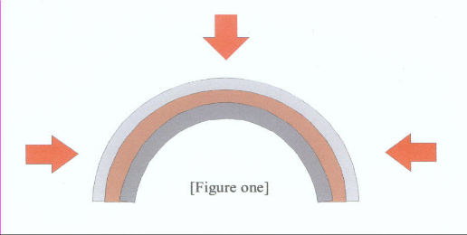
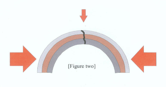
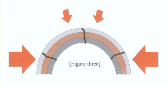
The Amphibian Era, that magical time when land first began to emerge from the center of the Sunny Ocean approached, some percentage, perhaps as much as 25 to 50 percent of the water that had originally blanketed the Sunlit Hemisphere, had frozen, and remained frozen, in the form of the Glacier Girdle. And the great weight of that unstable ice form commanded those geographical areas encircling the Earth adjacent to that great Glacier Girdle, to become the most geologically active regions that had ever come to pass on the Earth. Or at least, that had come and passed, since the Earth emerged from the throes of Creation. Although undoubtedly, local thawing caused the Glacier Girdle to temporarily recede, for a certain time, in particular areas. The relentlessly advancing ice would inevitably return. And the slow moving Glacier Girdle continuously, abrasively, routed deeper and deeper into the primeval Earth's crust, until eventually the eroding crust began to give way and a parallel crack opened under the Glacier Girdle, allowing ice and fiery lava to clash, repetitively, in violent, explosive confrontations of their antithetical characteristics. Untenable pressures generated by those clashes, drove not only superheated water, but likewise molten lava to subterraneously intrude extensively into the Ring Mountains, and spawn a multitude of volcanic and steamy geyseric eruptions. Massive magma and water flows, soon encircled the Earth, paralleling the Glacier Girdle. But beneath the placid waters at the center of the Sunny Ocean, for the first time on Earth, light begin to illuminate a portion of the ocean floor. A portion of the ocean floor that would steadily grow larger and larger, until millions of square miles lay bathed in eternal sunlight. Both primitive aqua flora and fauna, were quick to take advantage of this marvelous virgin Eden. They evolved like fruit flies, and multiplied like rats in a granary. There was, in a very short time on an evolutionary time scale, a very beautiful biological diversity thriving on Earth. And contrarily to what you have been taught, all this came to be long before there was any land that amounted to much, which was suitable for habitation. But continents were truly in the making, as the final curtain began to slowly descend upon the weaning Aqua Era. The Glacier Girdle that encircled the Earth corseted it as snugly, comparatively speaking, as were the waists of America's wealthy southern belles during those, gone but not forgotten, enchanting horse and buggy days. It should be added if I dare, (forgive me ladies) the Glacier Girdle moved mass much more effectively and permanently, than did the whalebone corsets worn by those aristocratic belles. The Glacier Girdle was solely responsible for routing and washing the rock flour from the primeval Earth's crust, which now constitutes much of the continental shields. And by directing the subterraneous intrusion of superheated water and molten magma into the Ring Mountains, and adjoining primitive strata, the Glacier Girdle was indirectly responsible for leaching and separating the various elements derived from that rock flour. The Glacier Girdle wrought a great deal more. As said it was the Glacier Girdle which so shifted the Earth's center of gravity that the sea-floor, the first land, slowly emerged from the center of the Sunlit Ocean. As central east Africa, the area surrounding the original site of the South Magnetic Pole, rose to emerge from the Sunlit Ocean, the force of gravity magnified proportionally, in its effort to maintain the Earth's spherical form. And it was when those Crustal Plates began tilting in compliance with gravity's spherical inclinations that the continents, much as we know them today, began to take shape. Since the Pacific Ocean was much narrower, east to west, than the distance across the Sunny Hemisphere, the Glacier Girdles probably oppositely transposed sufficient pressures to form an apex in the center of the Pacific Ocean and create one of the first great fissures, which were to slowly encircle the globe. The great fissure that separated Africa from Europe was undoubtedly one of the first, if not the first crack to appear on the Sunny Hemisphere. The shifting gravitational attraction of the Sun, as the Earth continuously tilted on its axis, from winter to summer and back to winter, probably accelerated that rifting. At this late date there is little evidence left of some of the fissures that played a major roll in initiating the crustal plates tilting that helped shape our continents. Look at Antarctica. Maps of the Earth's ocean floors clearly show the rifts that circled Antarctica. But there is no sign of the great rift that ripped the continent apart, as it's edges tilted down with the subsiding Atlantic-Indian Ocean and East Indian Ocean Ridges. It is obvious that the rift is there, and was very active, it divided the continent. Now, only a hot lake in a frigid country, a wisp of smoke from a volcanic mountain, and a few other similar hints, reminds us that a great crack still lurks under the glaciers. A great many of the cracks in the Earth's crust, which allowed crustal plates to tilt down to the ocean's ridges, have never been found, much less documented, mapped. For example: The Owen fracture Zone extends on between Africa and Madagascar, to the Prince Edwards Fracture Zone. This Africa/Madagascar Fracture allowed The Madagascar Plate to pull away from Africa, as the East side of the plate subsided with the Indian Ocean Ridge. To explain the tilting of crustal plates, let us focus our attention on North America. In-The-Beginning, the Glacier Girdle that accreted in the area we now call North America, was situated just westerly adjacent of what is now the Rocky Mountains. [ As illustrated on the map. ] The depth of the strata, which formed the Ring Mountains in this area, leaves no room to doubt that the Glacier Girdle did remain at this location for millions of years, before it melted and reformed near what is presently the west coast of the United States. This change in North America probably came very gradually. Crustal plates move, tilt, very slowly, probably only inches per year, at most but a few feet. Therefore it probably took not only hundreds, or thousands, but perhaps millions of years for the Glacier Girdle to melt and reform on what is now the west coast of North America. But, what could cause thousands of feet, several kilometers, of ice that had remained stationary for millions of years to suddenly begin to melt? It was most likely a combination of events, all of which were the result of tilting crustal plates. On the world that I have described, all lines of force, namely the force of gravity attempting to flatten the Earth as it emerged from the depths, on the Sunny Hemisphere would have radiated from the original site of the South Magnetic Pole in Africa, out in a complete circle, to the Glacier Girdle. And likewise, the lines of force, weight oppositely transposed, from the Glacier Girdle would have all pointed inwardly, toward the South Magnetic pole. Where these two powerful oppositely transposed forces met, at what is now the Mid-Atlantic Ridge, they caused the Earth's Crust to apex. Actually rock formations bend very little before they break. The combined forces bent the crust, and the rock cracked. Once the integrity of the Crust was violated, the Glacier Girdle was tilting a crustal plate that reach from the Rocky Mountains to the mid Atlantic, about 3,000 miles [4,850 kilometers]of plate. Remember the plank and beaker full of ice. That would be like submerging the end of a 40 foot plank. Something would have to give, and it did, the crust fissured along the Appalachian Mountains, the coast of Africa and Europe, and allowed the Mid-Atlantic Ridge to settle. As the Atlantic Ocean basin subsided, it drained an ocean of water from the land, lowered the horizon, and exposed millions of acres of land that had been covered by water, to a never setting Sun. At the same time the Appalachian Mountains were slowly rising, higher into the eternal sun, and collecting more solar heat. Eventually water and atmosphere may have both circulated around the Appalachian Mountains, and expedited the Glacier Girdle's receding. The coal mines paralleling the East coast of North America, are the products of hot humid swamps, and pay mute testament to a climate that could have easily extended temperate conditions on passed the Glacier Girdle, and started the great thaw. Likewise the Rocky Mountain coal mines and millions of fossils, prove beyond a doubt that all the central United States periodically enjoyed a bountiful temperate climate for millions of years. A sphere is the most capable of all geometric forms, at withstanding equally applied external pressures. Whether it is the force of gravity on our globe, as the red arrows in [figure 1] crudely represent, or a thousand feet of sea water on a diving bell, a sphere can withstand incredible pressures. Pressure on one area of a sphere is actually oppositely transposed to help the sphere withstand pressure on the adjacent areas. But even the phenomenal strength of a sphere can be thwarted by what would be tenable external pressures, if those pressures are applied unevenly to different areas on the sphere. Uneven pressure like that depicted in [figure 2] above, which is supposedly representative of the weight of the Glacier Girdle and the strengthening force of gravity on the emerging terra firma, can oval a sphere and form a bulge, or an apex on the sides with less pressure. And any apex, in a rock formations equals, a crack, a fissure. Similarly, once the integrity of the sphere, the Earth's Crust, had been corrupted, had rifted, the crust had been robbed of much of its strength. And the force of gravity pressing down at the newly formed [North Atlantic Ridge] fissure had hundreds of miles of leverage to open fissures running parallel to the ridge. And thereby allow the newly formed rift to begin settling. [figure 3] Once the rifts had opened and the Mid Atlantic Ridge began to settle, it continued subsiding for millions of years. Until, at the onset of the Mammal Era, the Atlantic Ocean was actually deeper than it is today. The Mid-Atlantic Ridge is now slowly rising. When land first appeared in the middle of the Sunlit Ocean, it was not just one small island that slowly emerged to dry in the sun, and become out of bounds to the aqua flora and fauna that abounded in the surrounding waters. Thousands of square miles, many thousands of square kilometers of the ocean floor, that had bathed in the penetrating rays of the Sun for an eon, and was teeming with aqua life, rose slowly to meet the placid surface of the Sunny Hemisphere. Eventually plants grew up through the shallow water to reach the surface of the Sunny Hemisphere and adapted to absorb sunlit directly. Those first surface plants had many advantages over their ancestor's strictly aqua existence. One of the greatest was they could fan out to shade the water and smother their competition. But, evolution is a story of one-upmanship and soon the other plants that survived, just rose above the water, where there was an unlimited supply of sunlit. Once hardy plants were growing above the water, it was just one small evolutionary step, to step out onto dry ground. Of course many of the plants that had evolved in those shallow sunlit waters survived by moving into deeper water around the perimeter of the emerging land and lived on to eventually spread worldwide. Animals found life, in the shallow water, on this emerging 'Alphaland,' becoming more and more confining. Not only, was the water level falling, as the plants grew thicker, but the plant stems were steadily growing larger and stiffer. And when it rained hard, the water moved from the center of the emerging continent flowing centrifugally toward the perimeter and deeper water. This new moving water had properties foreign to the waters of the Sunny Hemisphere, and stirred up silt and debris, muddied the water, and made it hard for animals that had evolved in placid waters to see and breath. Great trails and tribulations appear to be the mother and father of evolution. |
|
"Grandpa Nate's
Legacy" The only true account of our Earth's trek through time. CONTINENTAL DRIFT = EARTH'S GREATEST HOAX . By Grandpa Nate |
|
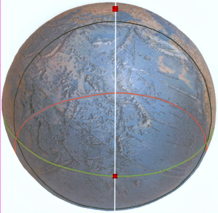
Were
you aware that the
shores of the North Pacific and South Pacific Oceans are congruent with two overlapping circles? The black ring circling the North Pacific [right] and the red ring circling the South Pacific [below] clearly demonstrates how those two circles overlap. A common bisector of the two circles, the green line, traces the site of the Earth's original Equator . And if we bisect that portion of the Equator within the circles, as the white line does, we can geometrically locate the site [the red square] of the original North Magnetic Pole. T he same site scientists had carefully ascertained was the original North Magnetic Pole, by palo magnetic investigation, long before Cox, Doell and Cohorts began to skew Polar History, in their attempts to bolster the Theory of Continental Drift. |
|
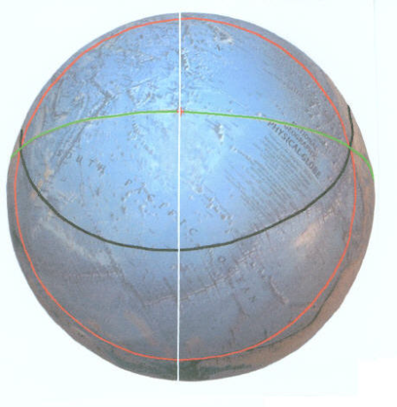
I
f the
white bisector of
the Equator is extended on around the Earth the two points on that white line furthest from the Equator are the original sites of the North and South Axis Poles. The red square, at the Northwest corner of the Sea of Okhotsk, [directly above the black ring on the above image] is the site of the original North Axis Pole, and later became home to the North Magnetic Pole . This book carefully explains these revelations. Why these circles are where they are, and how these circles dictated where the Axis and Magnetic Poles were located. I t even carefully explains why the Magnetic Poles moved, to join the Axis Poles. And this is just one of several extraordinary facts, explained in this book, which will inevitably rewrite Earth History. |
|
Grandpa Nate wrote this book, Grandpa Nate's Legacy, for his children, grandchildren, great-grandchildren, and hopefully, for generations to come. The first 10 of the book's 14 chapters painstakingly, step by step, details Earth's true History, before veering off light-years onto other subjects. Grandpa Nate's Legacy, explains how our Earth, a near perfect sphere covered almost evenly, with about 9,000 feet of water, was transformed into the World we know today. Grandpa Nate's Legacy, is not just some short, quickly assembled, essay. It represents a lifetime of study, and contains well over 60,000 words, over 150 pages of Courier New 13 Print, and I must concede, a host of rather sorry illustration's. |
|
The Truth It is often lamented that the truth is in very short supply these days. The "Powers That Be" do rigidly control our media and indubitably, in today's World, most news is subjected to considerable subterfuge before it is relayed to the people, by any news media. Our American Politicians' success hinges on their ability to spin the truth, to hide the truth in double speak. Or to blatantly tell the truth, their success hinges on their ability to lie. And our politicians are not the only government officials to debase the truth. The Republican Party, wielded such tyrannical power that representatives of NASA, EPA, the U.S. Geological Survey, numerous toady college professors, and a horde of other professional people, who's jobs depend upon government appropriations, all deliberately spun the truth, and vehemently denied our Planet was over heating, because of carbon dioxide and other toxic gases, being recklessly spewed into our atmosphere. To avoid investing in "Global Health and Prosperity," to avoid spending the money, for technological research and the antipollution equipment, needed to curtail global warming: Big Business, the conglomerates that own our politicians, were willing to risk sending the only inhabitable Planet that we are aware of, down a path toward a fiery hell, which may very well, yet instigate a mass extinction. It is hard to believe that there are people in this world that are so dedicated to profit, to the bottom line, that they would stupidly risk our beautiful Earth, to enhance their annual gain. Yet, by far the most harmful form of misrepresenting the truth is teaching our children that some hyped theory, like the "Theory of Continental Drift," is a Scientifically Proven Phenomenon. KNOWLEDGE CEASES TO GROW IN MINDS THAT HAVE ACCEPTED FALSE ANSWERS. |
|
Earth's Geological History, as presently taught in our schools and universities, is nothing more than a modern myth. It is just an elaborate story [ conjured up by innumerable contributors over a dozen decades ] to explain how the Earth arrived at this point in time, in its present condition. It should not strike us as incredible, or even unlikely, that our society formulated a fallacious story to explain the origin of our Earth. Every society that ever existed upon this Planet, and left a decipherable record, either adopted, or made up a story which accounted for the Earth's presents. Neither should it surprise us to learn that our version of Earth History is just as wrong, as were those [now] ridicules tales conjured up by those societies we sprang from. Nor should we forget that the Egyptians, Greeks, Romans, Celts, Ancient Chinese, Mayans, Aztecs, and the thousands of other peoples who have inhabited this old Earth, all believed that they were the ultimate chapter in human history. And that they were just as profoundly confident, as are our prestigious Geology Professors teaching their malarkey, that they had their World " all knowed-up ." Unlike "Grandpa Nate's Legacy," there will be no attempt made here to prove that the "Earth History" presently espoused by the enlightened World, is based upon unproven, distorted data, and fallacious theories. This essay is only meant to be, the first true, quick, sketch of our Earth's trek through time. But this story is supposed to challenge your concept of Earth History: So please! Do not conclude that this story is not worth reading the first time you find a statement, "WHICH YOU JUST KNOW IS NOT TRUE." Please First read the whole story, then criticize until you lose your voice. Just set back, relax, open your mind, and enjoy. [Even if you don't buy it; its a great story.] |
|
Earth History Recap What ever dramatic events took place, to account for our Earth's mass, remain hidden in the mists of time. We could speculate endlessly about how the Earth came into existence: Did it slowly accrete from dust orbiting the Sun? Or was it perhaps splashed from the bowels of Jupiter, along with the Icy Europa, by some swiftly moving interloper from Outer Space? Or could the Earth just be a lonely passer-by, which veered to close and became snared in our Sun's gravity. The possibilities that could account for our Earth's mass are endless, but any discussion of them would be just idle speculation. For there is not one iota of evidence, concerning the Earth's origin, to hang a theory on. Since we don't know how the Earth originated, our story must begin with the Earth already in place. We could dwell upon whether or not the Earth's crust was ever hot enough to convert all of its waters into steam. But lacking a shred of evidence concerning that subject, it too would be just so much more idle speculation. So let's skip it. The oldest rocks ever found [ rocks scientists claim are between three and four billion years old ] have all been exposed to sufficient heat to badly deform, and metamorphose them, rendering them useless as evidence about the environmental conditions during those long ago eras. Their condition does indicate that the Earth once had a much thinner, warmer, crust than it now has, and their residual magnetism does collectively point toward the past location of the North Magnetic Pole. Actually, although it is seldom acknowledged, the Earth by all indications had a thin enough crust, four billion years ago, for gravity to have formed it into a near-perfect sphere. A sphere almost evenly covered with about 9,000 feet [3,000 meters] of water. Few scientists have ever dared to even stick a toe into this subject: Because the hypothesis is in accord with the biblical, "Genesis'," account of Creation. Such an Earth does not appear to have been the most ideal place for life to originate. Neither does it leave open any possibility that " In-the-beginning " there was some great super continent, a Pangaea. The truth is, at that point in time,the crust of the Earth wasn't strong enough to support a continent. And of course, accepting this hypothesis leaves us with an age-old enigma to explain: "Just how did all of Earth's land, continent sized chunks of the ocean floor, get levitated above sea-level?" There is sufficient evidence now available to unravel the Earth's Real History. First we must set aside our own predispositions, objectively weigh the meager magnetic evidence available in the Earth's primeval rocks, to ascertain the original site of the North Magnetic Pole. And then geometrically chart and interpret the lay of Earth's lands: And almost magically, the chapters of early Earth History will begin to unfold. "In-The-Beginning" the Earth was round and featureless, a near-perfect sphere blanketed within an 'Endless Ocean.' Originally there were no continents, not even a jagged mountain range rose above the sea to bask in the Sun, or eternal darkness. The Endless Ocean was the Earth's only feature for well over two billion years. Some volcanic islands possibly emerged from the depths over such an eon, but millions upon millions of years has eroded, all traces of them, from our view. The "Bible" states that originally: "Darkness lay upon the face of the deep." And In-the-beginning total darkness did cover half of the Earth. [And all land was buried deep within a cold, dark ocean.] For the first nine-tenths of Earth History the Earth only rotated but once a year and was so synchronized with the Earth's orbit that the sunny-side continuously faced the Sun, while the other side lingered in eternal darkness. |
|
The principle presented in the above verbal enhancement is a greatly simplified paradigm of the events that lifted the lands, we now call continents, out of Earth's primitive Endless Ocean. Our Earth now rotates once a day, once every twenty-four hours. As it is more than 25,000 miles[40,225 kilometers] around our planet at the Equator then, obviously any given point on the Equator is moving in excess of 1,000 miles [1,609 kilometers] per hour. The rotation of our Earth and the fact that the atmosphere surrounding Earth follows the surface of the rotating planet imperfectly, accounts for the Prevailing Winds, and in one way or another instigates nearly all of the severe weather changes, we now endure. Such was not the case on the Primeval Earth, of eras passed. With one hemisphere continuously facing the Sun, almost perfect atmospheric conditions prevailed. Calm was surely the order of the day. And that first day on the "Sunny Hemisphere" lasted for more than three and a half billion years, throughout the first nine-tenths of known Earth History. As sunshine relentlessly heated the central water and atmosphere on the Sunny Hemisphere, the air continuously expanded, lightened, and ascended as it warmed. And in so doing directed a permanent centrifugal flow of the upper atmosphere toward the outer edge of the Sunny Hemisphere, toward the cold, dark side of the planet. On the dark side of Primeval Earth a reversed scenario unfolded. As the upper atmosphere descended below the sunny horizon, the air cooled, contracted, grew heavy, and descended to lower altitudes, where switching directions, it flowed back across the surface of the water, to the Sunny Hemisphere. Subsequently, an almost perfect atmospheric circulating system, was established. Wherein there were massive quantities of warm, moist air in the upper atmosphere flowing away from the Sunny Hemisphere to the cold, dark side of Earth. Where cooling it dropped its moisture, before returning cool and dry to the Sunny Hemisphere. Throughout the billions of years that elapsed between, the eon before Earth's first living-cell divided, until just minutes before the last dinosaurs died, an atmospheric circulation mode, basically as depicted, endured. The Endless Ocean also circulated in a mode, very similar to the way the atmosphere circulated. Great quantities of water around the central section of the Sunny Hemisphere, heated by the tireless Sun's rays expanded, became lighter, and spread centrifugally over the more dense, heavier, waters of the cold, Dark Hemisphere. And also like the atmosphere, the frigid water of the Dark Hemisphere steadily flowed back under the warmer water on the Sunny Hemisphere. And thereby completed an almost perfect oceanic circulating system, for primitive Earth. But, massive clouds continuously formed on the Sunny Hemisphere. In fact, clouds actually controlled the temperature on the Sunny Hemisphere. And in so doing, undoubtedly accelerated the growth of the Pacific Ice Cap, as it spread across the Dark Hemisphere. To elucidate, the Sun shining continuously upon the waters of the Sunny Hemisphere, steadily raised the temperature of that water, until the waters reach a temperature where great quantities of it evaporated. With those great quantities of evaporated water, moisture in the air, massive clouds formed to shade the water and reflect the searing sunrays back into space. So shaded, the slowly circulating water, cooling, would then begin to evaporate more slowly. And thereby, generate less cloud cover, and again let through more sunrays, which would again raise the temperature of the water. In this way, clouds rigidly regulated the temperature on the Sunny Hemisphere. To reiterate, the primeval Earth had an almost perfect, atmospheric circulating system. Except for the fact that the aforementioned temperature-regulating phenomenon did not allow the Sunny Hemisphere to absorb the massive quantities of heat that would have been necessary to keep the Dark Hemisphere warm, above that temperature at which water freezes. And so it was, that from In-the-beginning, the temperature on the Dark Hemisphere steadily fell, and the ice cap on the Dark Hemisphere steadily grew. Until eventually, ice covered the entire area now encircled by, that which is often referred to as, The Ring of Fire, until the Pacific Ice Cap of the Dark Hemisphere became transpacific in scope. As snow continued to fall upon the outer edge of the Pacific Ice Cap, great quantities of it began to accumulate, compress under its own weight, and form more ice. That ice, as it grew thicker and thicker, by continued accretion, became the first icebergs on Earth. As those bergs thickened, they settled, deeper and deeper into the Endless Ocean. Until eventually, the whole belt of ice, was but one long, endless ice berg circling the globe and resting upon the ocean floor. It may sound strange, but is nevertheless true, the ring of volcanoes circling the Pacific Ocean, the so-called "Ring of Fire" could have once far more appropriately been dubbed, 'The Ring of Ice.' The warm moist atmosphere never intruded far over the frigid Pacific Ice Cap. Over 90 percent of all the snow that fell on Primitive Earth probably fell in a belt, seldom over a thousand miles wide. And as that ring of ice grew higher and higher above sealevel, it set heavier and heavier upon the ocean floor. Until eventually the ever-thickening ice towered thousands of feet above the surface of the Endless Ocean, and spread, flowed at its base, under that great weight, as all glaciers flow. The ice-belt, oceanic glaciers, had faults, or cracks in it where the various sections had settled and/or spread at different rates. As the oceanic glaciers spread at their bases, much that spread toward the Sunny Hemisphere melted as it extended into the warm circulating water. While the ice that spread into the frigid waters of the Pacific Ocean melted much more slowly, and spread as weight and time dictated. Hence, the Glacier Girdle was shaped more like a right trapezium, with its most-perpendicular side facing the Sun, than like an isosceles trapezoid, as would a girdling glacier spreading evenly in both directions, where everything on both sides were equal. From the moment ice first touched the ocean floor, two physical phenomena commenced functioning, that would forever change the landless, Endless Ocean. As mentioned, the Oceanic Glaciers flowed at their bases, much as continental glaciers flow. Except that the 'Glacier Girdle' continued for many, many years to accumulate snow, grow steadily heavier, and extend its base, across the ocean floor. And as the Glacier Girdle spread, it bulldozed great quantities of oceanic sediment along ahead of the moving ice. The second, and most important, phenomenon to commence functioning was that, as ice set upon the subterraneously heated ocean floor, it melted. The resulting water under the oceanic glaciers was under an unbelievable pressure, thousands of pounds per square inch. And as it vented, it carried with it, not only any sediment that the bulldozing action of the spreading Glacier Girdle had missed, but also continuously washed out, eroded, tiny granules of the crust from under the Glacier Girdle. The first land to break the surface of the Endless Ocean was a blend of the aforementioned sediment bulldozed up by the Glacier Girdle and minute particles of primeval crust, washed from under the glaciers. In the twilight of the Sunny Hemisphere, many small islands, always dwarfed by the massive oceanic glaciers they paralleled, were pushed above the surface of the Endless Ocean, only to be washed away, again and again. And the tiny islands that appeared and vanished with such regularity were but surface hints, of the mighty, endless mountain range that steadily grew, beneath the surface of the Endless Ocean, at the foot of the Glacier Girdle. The tiny portions of the oceanic crust washed from under the Glacier Girdle, and the original oceanic sediment was for the most part, very fine grained, predominantly microscopic particles. And much of it, once disturbed, was carried away by circulating ocean currents, and deposited far from the Glacier Girdle, was spread across the Sunny Hemisphere. And so, the most primitive strata, resulting solely from terrestrial phenomena, were deposited. Strata, for the most part consisting of fine-grained sand, deposited upon the most primitive strata pays mute evidence to the endless mountain range, which paralleled the Glacier Girdle. For that fine-grained sand was the product, of phenomena relative to that mountain range which circled the Earth. In spite of the fact that the endless mountain range that ringed the Earth, was in a climatic zone where it rained or/and snowed, continuously, it slowly but steadily emerged from the Endless Ocean. Until eventually, it became a permanent divider, an unbroken mountain ring, between the frigid water of the Pacific Ocean, and the warm inviting waters of the Sunny Hemisphere. And in accord with 'Genesis' account of creation, the Earth's waters were parted. And the endless ocean was, no more. |
|
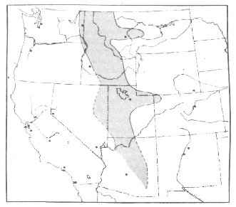
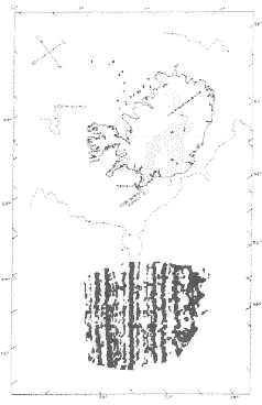
THEIR CAPTION Late Precambrian sedimentary rocks accumulated to thicknesses up to 50,000 feet in the basin shown here. Comparison with other maps in this chapter shows that younger structural elements cut across this trough. The location of this trough was reconstructed from extensive outcrops in the northern Rocky Mountains, and scattered outcrops in Arizona and Nevada. Other Precambrian sedimentary rocks are found in the oldest parts of the geosynclines. The western boundary of this basin is less well known than the eastern. End of Caption |
|
[Copied from the net: Dated:9/2002. 'A Millennium of Geomagnetism' By: David P. Stern, Goddard Space Flight Center, Greenbelt,Md. This is a copy of the original map made by [James Heirtzler, 1968] showing zebra stripes on the Reykjanes Ridge, South of Iceland. As anyone can see, this is not an exact record of anything. And this chart was hand painted by people trying to prove Continental Drift. Any claims about zebra strips extending on across the ocean floors are 100% pure malarkey. |
|
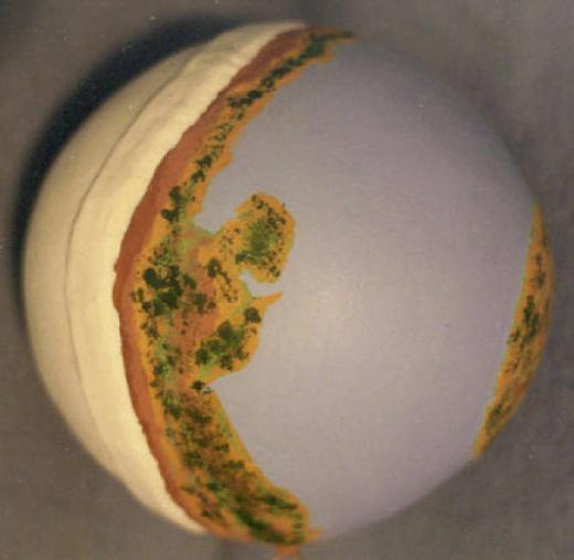
This
picture is of a model of early Earth and the Glacier Girdle. The Glacier Girdle was positioned on the model, according to the present edges of the Pacific Ocean. So, it should be a reasonably true representation of the Mid-Amphibian Era. Of course the Southern slope of the Glacier Girdle facing the Sunny Hemisphere, was the only facet of the glaciers to ever even receive twilight. Direct sunlight may have melted some ice, during the springs and summers, which undoubtedly accumulated every winter, near Poles. |
|
Copied from General Geology, chapter, 'Continental Drift,' by Robert J. Foster. Copyright 1969, by Charles E. Merrill Publishing Company, Columbus, Ohio. The earth's magnetic field is believed to originate from electric currents in the core. It is a well-known law in physics that a moving current creates a magnetic field, and conversely, a current is induced into a conductor moving in a magnetic field. Electrical currents in the core could start in a number of ways, such as through a weak battery action caused by compositional differences. Once started, these currents could be amplified by a dynamo action in the Earth's core. A dynamo produces electric current by moving a conductor in a magnetic field. In the earth the core is the conductor, and because it is fluid, it can move. The mechanism envisioned is similar to a dynamo, which produces an electric current, and this current is fed to an electric motor that drives the dynamo. Friction and electrical resistance would prevent such a perpetual motion machine from continuing to operate unless more energy is added. In the earth this additional energy can come from movement of the fluid core. Calculation shows that very little additional energy needs to be added in the case of the earth; and the necessary energy for core motion, probably in the form of convection, could come from many sources. Thus a current is somehow started in the Earth's core, and this current produces a magnetic field. The conducting core moves through the magnetic field, and a current is induced in this part of the core, starting the whole process over. In a stationary earth, the movements of the core would probably be more or less random and the magnetic fields produced would probably cancel each other. The rotation of the earth tends to orient the motions of the core so that the motions and, therefore, the currents are in planes perpendicular to the rotational axis, Viewed from outside the earth, the overall current produced would be parallel to latitudes. Such currents produce a dipole magnetic field red on the rotational axis. A field produced in this way would have all of the characteristics of the Earth's magnetic field. The main field would be a dipole field; superimposed on this would be other fields caused by variations in the core's motion. This can account for the variations in intensity and location of the Earth's field. The Earth's dipole field does not coincide with its rotational axis, however, as this theory predicts, although if averaged over a long enough period, the dipole field would perhaps appear centered on the rotational axis. The positions of the magnetic pole deduced from remanent magnetism of Pleistocene and younger rocks cluster around the rotational axis, suggesting that this is true. The present [in 1969] dipole field is 11.5 degrees from the rotational axis and lies northwest of Greenland, some distance from the magnetic north pole, north of Canada. End of copied Material. If one side of the Earth faced the Sun for the first nine-tenths of Earth History, then we can forget about claims that the Earth's Magnetic Field is somehow mysteriously generated inside the Earth. Scientists believed, until the Mariner 10 Space Craft proved them wrong, that Mercury could not have a magnetic field, because it revolved too slowly. They thought until about 1965 that one side of Mercury always faced the Sun. Actually, Mercury revolves around the Sun every 88 days, and rotates once every 58.6 days. It rotates three times, while orbiting twice around the Sun. I never did believe that malarkey, about the Earth's Core being a dynamo anyway, it sounded too much like Venus, to me. I guess though, when you already have a Continent-Eater inside the Earth, conjuring up a dynamo, and the power to energize it, are small potatoes. The following is a lame attempt to explain Mercury's Magnetic Field. The paragraph below is copied from: 'The Cambridge Encyclopedia of Earth Sciences' Chapter 37,'The geology of the solar system,' Published jointly by: Crown Publishers Inc. One Park Avenue, New York N.Y. & Cambridge University Press, 32 East 57 Street, New York, N. Y. Mercury's magnetic field. The Mariner 10 spacecraft revealed that Mercury has a magnetic field with an intensity of only about 1/100 that of the Earth, with north and south poles closely aligned with the rotational axis. This discovery was not anticipated because it was considered that Mercury's slow period of rotation would preclude the operation of a geomagnetic dynamo similar to the Earth's. As suggested in the case of the Moon's field it is possible that Mercury's magnetic field is essentially a fossil one acquired early in its history and never subsequently lost. Since Mercury is so close to the Sun it seems almost certain that it must have been affected by the Sun's powerful field. End of copied material. All of the magnetic fields that I know of, and understand, were initiated by electric energy. You can magnetize a screwdriver by simply wrapping an insulated wire around it a half dozen times, and arcing [momentarily touching the positive and negative anodes with the ends of the wire] on a twelve-volt battery. Logically, we should expect that the driving forces that maintain the Earth's Magnetic Field should be just as easily explained. Granted, the Earth's Magnetic Field is a whole lot larger than the magnetic field surrounding the end of a screwdriver. But the principle, and the 'laws of physics' that account for their existence, are exactly the same. The odds greatly favor the probability that the driving force behind the Earth's Magnetic Field arrives on Earth via the Solar Wind, or at least, along with the Solar Wind. More than 99 percent of all energy in the entire Solar System, originates in/on the Sun. Electricity does not like heat. Or rather, heat increases resistance to the flow of electricity, in any material. For example, the hotter an electrical wire is, the less amperage it will carry. Actually, the very thought of moving electricity though anything, as hot as the center of the Earth, much less generating electricity in that environment, is preposterous. Any electrical energy emitted by the Sun, and attracted to the Earth's mass, would move through the cool upper strata, circling the Earth's melted interior and hot core. In all probability, the Earth's Magnetic Field is powered by electrical energy emitted by the Sun. This atomically generated electrical energy is probably nearer akin to static electricity than any other known form of energy. Think of this energy being constantly, lightly sprinkled on the side of Earth facing the Sun, like some slow, steady electrical rain. But this electricity does not spread, or run around the Earth at the speed of light, like electricity in a power-line. It accumulates in receptive areas until it accrues enough charge, to motivate it moving onto an adjacent area with a lesser charge. There it charges until it has enough charge to move on again, and so on, and on, until it has circled the Earth. Before the Earth started turning once a day as it does now, electrical energy which was attracted to the Earth's mass, moved from the Sunny Hemisphere around the Earth and was eventually emitted from that point on Earth which was furthest from the Sun, back out into the Solar Wind. Later, when the Earth's Magnetic Field began to materialize that point become the North Magnetic Pole. This consent movement of electricity from the vicinity of what became the South Magnetic Pole, to the North Magnetic Pole instigated, oriented and maintained the Earth's primeval Magnetic Field. This explains why the locations of the primeval magnetic poles, were those two points on Earth, which were the closest, and the furthest, from the Sun. Once the Earth started to spin, most of the electrical rain descended, like the Sun's life-sustaining rays, on the equatorial regions. Very little to none reach the North or South Rotational Axis Poles. Therefore, the receptive areas in the equatorial region began to bleed off their charges to those areas that were closer to the Rotational Axis Poles. Soon energy from the equatorial regions, around the World began to migrate toward the Rotational Axis Poles. Once aid flow of energy became established, it redirected the Earth's Magnetic Field, aligning it with the Earth's Rotational Axis. Why the North Rotational Axis Pole, also became the North Magnetic Pole is a little harder to explain. With all things being equal, the South Rotational Axis Pole had a fifty-fifty chance of becoming the North Magnetic Pole. There are those who claim that the North and South Rotational Axis Poles divide up the honor of hosting the North Magnetic Pole. They maintain that the positive and negative magnetic poles, switch places periodically, kind of similar to alternating current. As previously addressed, the theory of the poles switching, more than a hundred times, sounds like a vacuous deduction, to me. It was made up by the same people that deduced the continents on this Earth are floating around like so many rafts in a hurricane. It does appear that the North Magnetic Pole could be at/near the North Rotational Axis Pole, just by chance. It is also possible that because of the larger landmasses in the Northern Hemisphere, it attracted more electrical energy than the Southern Hemisphere, and therefore, became sated and began to emit energy back into the jet stream, first. Once the flow of electrical energy from the North Hemisphere started, the energy south of the Equator would have followed, and set the stage to redirect the Earth's Magnetic Field, and align it with the Northern Axis Pole. Whether the Earth's Magnetic Field maintained its integrity, while it rotated ninety degrees to align with the Earth's Rotational Poles, or was extinguished when the Earth suddenly started to spin, and regenerated, and aligned with the Rotational Poles, is a real poser. Whichever scenario is true, the realignment undoubtedly took place in a month or so, likely in matter of days. On a geological time scale, that is a blink of an eye. Not nearly time enough, to expect that any appreciable evidences would ever be found under normal circumstances, to shed any light on the event. But the Dinosaur Era ended during the most catastrophic event the continents on this Earth have ever suffered, so there may be some evidence surface indicating how the Earth's Magnetic Field reacted during these violent times. There is no doubt that erupting volcanoes, magma flows and many horrific earthquakes marked the time. Remember: On a globe; I drew two circles, covering the Pacific Ocean, then drew a common bisector across where those circles overlapped, to find the original location of the Earth's Equator. Finding the center of that segment of the equatorial line, gave me the point on Earth furthest from the Sun, and I then drew a perpendicular line through that point. It was a simple matter then to extend the Equator, and the perpendicular line, on around the globe. At that point where the perpendicular line re-crossed the Equator, was the center of the Sunny Hemisphere. Said perpendicular line also bisected the Earth, and the two points furthest from the Equator on that bisector, marked the sites of the original Rotational Axis Poles. The above was reiterated to establish that the two points on Earth, which are furthest from and nearest to the Sun, the sites of the original North and South Magnetic Poles, and the sites of the North and South Rotational Axis Poles, were objectively located, by geometric calculation. That point is important. Because if we chart the movement of the North Magnetic Pole, from the original site on the Equator in the middle of the Pacific Ocean, to the original site of the Rotational Axis Pole, and then to the present Rotational Axis Pole, it parallels the route scientists charted via paleomagnetic studies . |
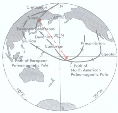
|
Copied from Introduction to Geology, Copyright 1968, by Prentice-Hall Inc.Englewood Cliffs, NJ. [Cox's Statement] Paleomagnetic measurements of rocks from North America and Europe show the paths followed by the magnetic poles of these two continents from Precambrian times to the present. [Redrawn from Cox and Doell] End of Copied text. |
|
Prior to Cox and Crew's first map advocating Continental Drift, the Scientific Community were in agreement that the North Magnetic Pole had remained stationary throughout the first nine-tenths of Earth History. Cox had the lines in his drawing meet at the original site of the North Magnetic Pole, because the result of many field studies designated the site, as the location of the original North Magnetic Pole. Cox and Crew claimed to have found rocks, somewhere, with the proper remanent magnetism, which warranted drawing such a map. As far as is known no attempt was ever made to verify their research. |
|
Copied from 'Physical Geology,' copyright 1969, by John Wiley & Sons Inc. New York, London, Sidney. Curves that trace the inferred path followed by the North Magnetic Pole through time, based on paleomagnetic measurements in North America (blue curve) and Europe (black curve). After Eocene time the two curves merge. (After Northrop and Meyerhoff, 1963 based on Cox and Doell, 1960.) End of copied text |
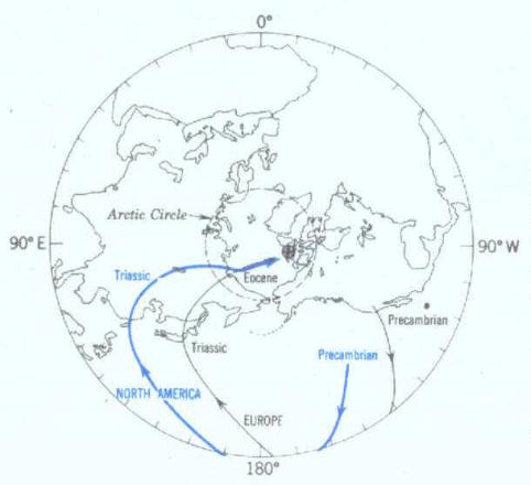
|
Please note, how the location of the North American and European paths, have been switched on these maps. The 'Introduction to geology' map has the American path on the inside, as the paths converge. On this map from the: 'Physical Geology,' forth edition, copyright 1971,by Prentice-Hall Inc. Englewood Cliffs, New Jersey , It is on the outside. A sceptic might wonder if they may have intentionally switched the paths so they could add the following paragraph. Copied notation, concerning this map. Polar wandering support's continental drift. The most logical explanation is based on the interpretation that Earth's magnetic field has remained an axial dipole and that only one north magnetic pole existed. The divergence in reconstructed positions of this pole could have resulted from progressive drift of the two continents away from each other. Ancient pole positions reconstructed from the two continents can be made to coincide closely if drift is assumed and if the continents are moved back to the positions they are thought to have occupied before the drift began. End of copied text . |
|
I read a story a couple or three years ago, about the end of the Dinosaur Era. It came complete with an artist's conception of a duck billed dinosaur watching a comet falling from the sky. The story related how a strange light appeared in the sky, which steadily grew brighter and brighter until it illuminated the night skies and paled the Moon with its brilliance as it entered the Earth's atmosphere. They estimated that on its final plunge to Earth, for a few minutes the comet brilliance, and the heat it emitted, far exceeded that of the Sun. The story went on to explain, how the comet on smashing into the Earth, belched up this gigantic cloud of dust and debris. Which in turn, spread over the Earth, blocked Sun's rays, and fostered the frigid ice age, that exterminated the dinosaurs. There have been a hundred of versions, of the above story, published. The theory has been so thoroughly accepted by the scientific community that millions of children around the world have shamefully been taught: It is the reason the dinosaurs became extinct. There is no greater sin in education than presenting some hyped theory to children, as a scientifically proven phenomenon. Knowledge ceases to grow in minds that have accepted false answers. The above story was not related because of any probability that it may be true. There are far too few clues supporting the theory, to give it any real credence. Yet the story of the comets approach does clearly allegorize the actual phenomenon that brought about the dinosaur's extinction. But the ever-brightening light that approached Earth was not a comet, and it could not have possibly paled the Moon with its brilliance. The approaching light was the Moon. And it passed so near to Earth that its gravitational pull sped up the Earth's rotation. The earth accelerated from rotating once a year, to rotating once every day, once every twenty-four hours. No Dinosaurs survived the catastrophic event. The 'Dinosaur Era' was over. The Emce, Earth/Moon close encounter wreaked incredible havoc upon the Earth, and never left the Moon unscathed. The Moon has a diameter of 2,160 miles, equal to about one-quarter of 7,926.4 miles , the Earth's diameter at the equator. As it rushed Earth on its original orbit, the Moon was probably traveling at a rate exceeding 40,000 miles per hour. The Moon's mean distance from the Earth is reportedly 238,857 miles . The orbit is quite elliptical, varying more than 30,000 miles, from a perigee of 216,420 miles , to 247,667 miles at their apogee. The Moon covers about 716,568 miles in 27 days, 7 hours, 43 minutes and a second or so, to orbit the Earth. So, the Moon is now circling the Earth at an average speed of about 26,248 miles per hour. The distance the Moon missed colliding with Earth is very problematic. But there undoubtedly were many catastrophic phenomena instigated by the emce. Still, it is all vary iffy. There are too many variables: The distance that separated the Earth and the Moon on their first, nearest perigee, and the rate the Moon was traveling, relative to Earth, on its first pass by Earth, is crucial questions. But only time, and a great deal of tedious research, can ever blueprint-exactly how, when, or where, all those horrific events unfolded. That said: In my mind's eye, the following paragraphs fairly accurately describe some of the Earth-shaking phenomena the emce likely triggered. [pronounced emcee] As the Moon passed by Earth, Lunar Gravity attracted the Earth's atmosphere, creating a huge atmospheric bulge, which raced around the Earth, follow ing the Moon , as it arced , around the Earth. This movement of the atmosphere generated winds with velocities far exceeding any, the primeval, placid Earth had theretofore experienced. Winds, which uprooted, leveled, and killed nearly everything in the storm's path. Wherever the moon passed over land it left a horrific path of total devastation in its wake. As the Moon passed over water, the same winds that wreaked havoc on land, created mighty storm surges, which flooded any coasts they encountered. The winds racing a long with the Moon, at hundreds of miles per hour, undoubtedly scooped up water and carried it thousands of feet up into the air. If any traces of water are ever found on the Moon, we could learn that the Moon acquired i t water during the emce . As the Earth's rotation accelerated rapidly, the water failed to keep pace, and all water on Earth flowed in a westerly direction. Actually the waters, South of the Equator was slung to the Southwest, while the waters North of the Equator moved Northwest. This water gathered speed and volume as it race for the Polar Axis, and met in a horrific collision water, ice and debris. |


|
Imagine
an aqueous planet with an orbit and rotation so synchronized that one hemisphere continuously faced its Sun, while the other remained frozen, frozen , in continuous darkness. |
|
Now
Imagine that ice begins to form on the cold, dark side of this planet. Compared to Earth the water and ice shown here are exaggerated by hundreds and are portrayed only for theoretical clarification. |
|
Eventually on such a planet the accreting ice would so shift the center of gravity, that land, the ocean floor, would divinely emerge from the abyss to bask in eternal sunlight. |
My Stats
<
My Stats

|
Hughes motto 'Y Gwir Yn Erbyn Y Byd' (That's Welsh) ['The truth against the world'] This motto is carved on fireplaces in the Hughes' old family home at Donnington Priory, Newbury, Berkshire, in Southern England. |
|
About two-thirds of the Earths surface is covered with water, and centrifugal force drew those waters that had been racing toward the Axial Poles, while the rotation of the Earth was accelerating, rushing back toward the equatorial regions. And it was not only, the quantity of water that was previously at the Equator, which rushed back to the region. Centrifugal force contributed somewhere close to another 45 feet, (15 meters) of water to the equatorial regions. Simply put, water like the aforementioned man, weighed less at the Equator than at the poles, and rose proportionately to compensate for the waters that grew heavier toward the Axial Poles. Diminishing, flood and ebb tides continued to ravage the Earth's coasts for a week after the emce phenomenon. A short time compared to the atmosphere, which failed to accelerate sufficiently to obtain any real stability for months. For the first week following the Moons passing, east winds far in excess of a hundred miles per hour buffeted the whole equatorial region. The lower atmosphere took months to accelerate sufficiently, for the winds to establish any semblance of wind patterns, similar to those we have today. Ten years after the Moon's first pass by Earth, as it passed perigee it was still creating tides two or three times as formidable as any suffered on Earth today. On the up side a full moon during a perigee, obliterated the stars from the night skies and illuminated the night nearly as light as day. A hundred years after emce, at a perigee, the Moon probably only appeared twice as large, than it does presently. The more oval the Moon's orbit was, the quicker it stabilized into a more circular orbit. For example, most of the change that occurred in the Moon's orbit during the first ten years, actually took place in the first year, of that ten-year period. Like wise, most of the change in the Moon's orbit which occurred in the first hundred years, took place during the first ten years of that period, and so on. A thousand years after emce, the Moon, at its perigee, likely only appeared to be a couple times larger, than our Harvest Moon does now on a clear night. The centrifugal force generated by the whirling Earth after emce, threw our world drastically out of kinetic balance, and instigated many untenable pressure changes on the Earth's crust. Indubitably, such a sudden, drastic, geological adjustment triggered innumerable earthquakes, and brought on a rash of volcanic activity. Instability of the Earth's crust was further heightened, and prolonged for many years, as the Glacier Girdle melted, and the coasts of the Pacific Ocean, released from the burden of the glaciers great weight, began to decompress, began to rebound. It is a bit hard to comprehend how much solid rock can be compressed, and rebound, when subjected to and then released from a great weight. For example, the land around the great lakes is still rebounding, rising, from the compression it underwent, during the last Ice age. Comparatively speaking, since the Glacier Girdle began melting, we could guess that the compressed rock under it has probably expanded hundreds of feet. But there is little data available to support such a hypothesis. Gravity tests do confirm that the area under the Ring-of-Fire, the area which was under the Glacier Girdle, is still heavier, is still more compressed, than the strata in the adjacent areas. We do know that areas, such as the Great Lakes area, do rebound after being compressed with glaciers. But our knowledge of how much, or how quickly rock formations will compress, or rebound, is very scant. Different types of rock formations probably compress and rebound, at different rates, and in varying degrees. For now, just saying the formations once covered and compressed by the Glacier Girdle, have rebounded a significant amount, and are still expanding is about all we dare declare. Actually a phenomenon of much greater consequence than the strata under the Glacier Girdle decompressing was initiated when the edges of the crustal plates, which had been tilted down by the awesome weight of the Glacier Girdle, begin to rise, to level. The edges, of both the oceanic and continental crustal plates that meet at the Pacific Ocean shores began to rise. |
|
The tilting of these oceanic and crustal plates activated numerous earth quakes and a string of volcanic activity that circled the Pacific Ocean, and ignited the so called, 'Ring-of-Fire.' Proof that crustal plates move, tilt very slowly, lies in the fact that the volcanic activity and accompanying earthquakes which encircle the Pacific Ocean, are still very active. Simply put, shortly after emce the atmosphere stabilized and cleared sufficiently, to enable the Sun to commence thawing the Glacier Girdle. As the Glacier Girdle melted, the edges of the adjacent crustal plates, relieved of their great burden of ice, began to rise. Actually gravity began to slowly re-level the plates and the aforementioned edges have risen continuously until this day. And they are presently still leveling at a rate sufficient to maintain a very active Ring-of-Fire. The lifting of the oceanic and continental plates where they meet at the shores of the Pacific Ocean are also responsible for creating the deep oceanic trenches. Obviously, the Earth's Crust cracked, for the most part, on the oceanic side of the Glacier Girdle, in the Western Pacific, and on the continental side of the Glacier Girdle, on the Eastern, or North and South American side, of the Pacific. The oceanic trenches were not created by any mysterious, unfathomable force, by any Devil residing deep within the bowels of the Earth. They have simply opened, as the edges of the crustal plates have risen. Before man made his first trip to the Moon, scientists estimated that the astronauts would find the Moon carpeted with from 6 to 15 feet [2 to 5 meters] of dust. They of course, made that assumption assuming that the Moon had been a companion of Earth for the last four or five billion years. According to our best radiometric tests, the Moon has been around somewhere, and most likely somewhere in our Solar System, for at least close to four billion years. That is time enough to gather a lot of dust, dust that for the most part blew off of the Moon, during emce. This Moon dust is what is responsible for the thin layer of iridium rich dust deposited at the K-T Boundary. |
|
Much of the Glacier Girdle likely survived the emce with little, if any, modification. It does appear the Glacier Girdle was probably breeched between the Philippines and Antarctica. Australia and the lands between those two sites appear to have been inundated with giant tsunamis that leveled the lands, and left great mountains of Pacific Ocean Ice in their wake. The face of the Earth between those two points was so modified, that it is hard to even tell exactly where the Glacier Girdle, or the lands, excepting Australia, were prior to emce. There is little doubt that for a hundred years after emce there were glaciers and great piles of ice at sea level, in the equatorial regions. In the Temperate Zones, sections of the Glacier Girdle lasted a great deal longer, lingering for hundreds of years. And undoubtedly, would have lasted even longer, perhaps thousands of years in the northern regions, had it not be exposed to the currents of the Pacific Ocean, which were steadily growing warmer. Many land animals survived emce, and lingered for years, only to slowly die off, and become extinct, simply because they failed to discover a niche, in which they could prosper. And/or because they could not adapt sufficiently, or evolve quickly enough to make them selves a place on the startling new World they now faced. Those animals, which did survive, underwent an extended period of accelerated evolution that stocked our Earth with a wide variety of strange new animals, which differed mightily from their predecessors. If you could totally objectively examine a randomly selected group of land animal fossils that lived before emce, and a similar group of fossils that lived since emce, you might, mistakenly, determine that you were examining fossils from two different worlds. Scientists have never even addressed, let alone explain, what could have so thoroughly redirected the course of evolution. There is one indubitable fact: No little bump in the side, or even an ice age on Earth, could have possibly so radically redirected evolution. Only a dramatic, permanent change in the Earth's environment could have instigated such an abrupt, permanent change in the course of evolution. In the Temperate Zones, sections of the Glacier Girdle lasted a great deal longer, lingering for hundreds of years. And undoubtedly, would have lasted even longer, perhaps thousands of years in the northern regions, had it not be exposed to the currents of the Pacific Ocean, which were steadily growing warmer. Marine species fared no better during emce than land animals. Like some land animals, quite a few marine species may have survived for some time, perhaps even scores of years, while their numbers steadily dwindled, before their species finally became extinct. During the emce, and during the next couple or three years that it took for the atmosphere to stabilize sufficiently to maintain permanently warm Edens along the equator, nearly 90% of all marine species became extinct. Which is quite comparable to about 85% of the land animal species that became extinct, during the same period. In the end, a total of about 15% of the marine families, and 25% of all land animal families were completely exterminated. Scientists claimed for many years, that no animal over thirty pounds survived the 'comet' that supposedly happened here on Earth. They have fudged a little during the last ten years or fifteen years and now, most scientists believe that the largest animals that survived the K-T event weighed around fifty pound. When we think of extinctions, the awe inspiring dinosaurs, and perhaps those ancient horrifying monsters of the depths that shared their world, usually are the first creatures that light up our minds. But the emce also exterminated about half the groups of tiny Cretaceous plankton, as well as many families of snails, sponges, bivalves, bony fishes and some families of mammals and birds. And that only names some of the faunas [animal life]that become extinct. The rest of the story is: That about half of all species of land and marine floras, [plant life] also became extinct during, or shortly after emce. It is highly probable, that many species of the life that flourished during the Cretaceous, only to became extinct due to the emce phenomenon, would have survived, had the Earth returned to a Cretaceous like environment, after the event. Permanent catastrophic changes in the Earths environment, is the real reason for the mass extinction. In plain language, had half of the dinosaurs living at the end of the Cretaceous Era survived the emce event, they all would have still inevitably, and quickly, became extinct. |
|
Simply put: Cretaceous Dinosaurs would have had a better chance of surviving in the proverbial Hell, than they had living on the new world the emce created. Catastrophic changes in the Earths environment is truly the mother of all mass extinctions, as well as accelerated periods of evolution. The marine environment, life in what had been the sunlit oceans, suffered as devastating an upheaval as that suffered by the land inhabitants. During and for some time following emce, only the strong and lucky survived. Just how much ice and waters of the frozen Pacific Ocean and the warm waters of Sunny Hemisphere were merged during emce will never be known. But undoubtedly a sufficient quantity, was sloshed together during the first day, to bring about a mass oceanic extinction. Eventually as the dust had settled, and the Sun grew warm, the Glacier Girdle began to melt, and the waters of the World's oceans continued to merged and began to circulate. The oceans on the Sunny Hemisphere throughout the Dinosaur Era were filled with warm, quite salty, mineral rich, water, compared to the frigid Pacific. Such was the water, in which the marine life of the Cretaceous had evolved and flourished. Once the Glacier Girdle was breeched, and the oceans began to circulate, the heavy, cold, comparatively inert, water from the Pacific Ocean slipped under the warm waters of the Sunlit Ocean and filled the ocean basins with frigid water. Probably within days, in a few weeks at most, the ocean depths of the Indian and Atlantic Oceans fell from a warm 60 or 70 degrees Fahrenheit, [16 to 21 degrees Celsius] to near freezing temperatures. Warm Atlantic and Indian Ocean water, teeming with life and spores was lifted, as the cold water filled the ocean basins, and spread out over the frigid Pacific Ocean water, and planted ancient flora and fauna onto many of the Pacific's warm, active, seamounts. The water in both the Atlantic and Indian Oceans, below a few hundred feet, simply became uninhabitable to most of the flora or fauna that had evolved in the Cretaceous. As the months and years passed and the oceans' waters continued to merge, marine life on Earth had but two choices, evolve and adapt, or become extinct. Both on land and in the sea, accelerated evolution soon adapted or replaced that which was, with that which is, and the Dinosaur Era was over. The Mammal Era had arrived. |
|
Want to save America ??? Interested in politics ??? Check it out: HTTP://voteagainsttheincumbents.blogspot.com/ Or, more Earth History? Try: HTTP://planetearthrevisited/ [YOU WILL PROBABLY HAVE TO COPY AND PASTE THIS ADDRESS.] |